

DataFarming Products
What product is right for you?
Whether you're a farmer, agronomist or corporate agribusiness,
we have the tools for you.
Farmers
Agronomists
Agribusiness
For Farmers – Start farming smarter
Recommended for you – beyond the basics
OPTION 1
Advanced Subscription
For occasional users or farmers wanting more detail.
- Pay only for what you use
- 15% discount on premium tools
- More image calculations, multiple field viewing, pdf maps, basic trials
OPTION 2
Pro Subscription
For high-tech farms or larger operations.
- Unlimited access to key tools — John Deere yield data, Trials, variable rate prescription maps & multi-year STACK analysis
- Expert support for data processing, conversions, and troubleshooting

Grow with confidence. Make better decisions from space to soil.
Did you know?
Most paddocks have around 300% yield variation.
- Reducing this variability starts with one thing: understanding the problem. Going to the right spots makes sure you are targeting the right input, in the right place, at the right time.
- But until now, the tools to help have been expensive, complex, and too time consuming to use. DataFarming changes all that — bringing precision to every decision you make in the paddock.
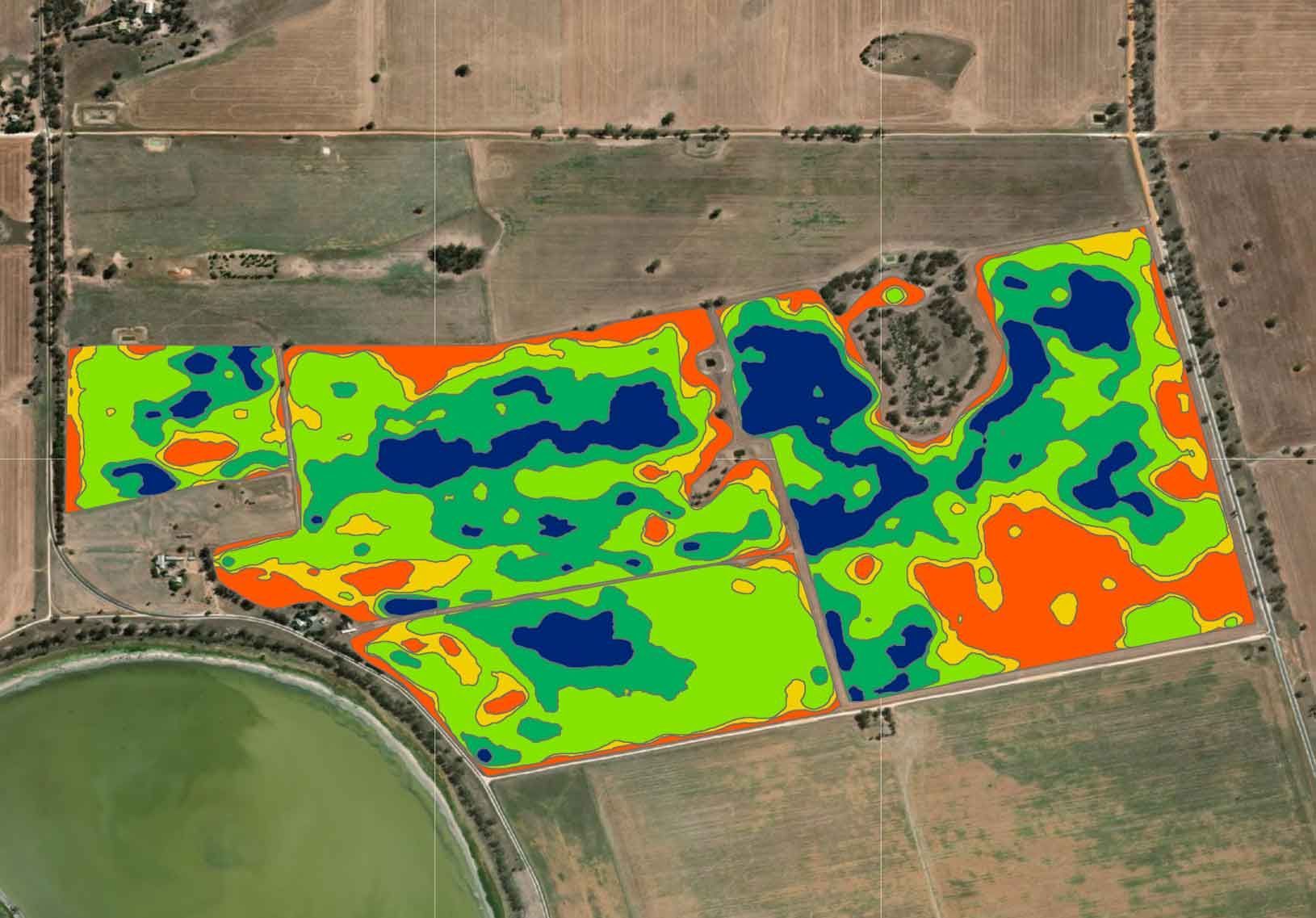
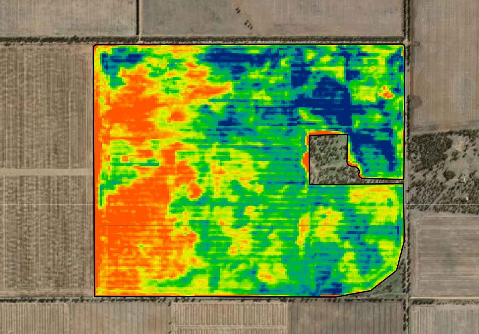
Unlock your soils' potential.
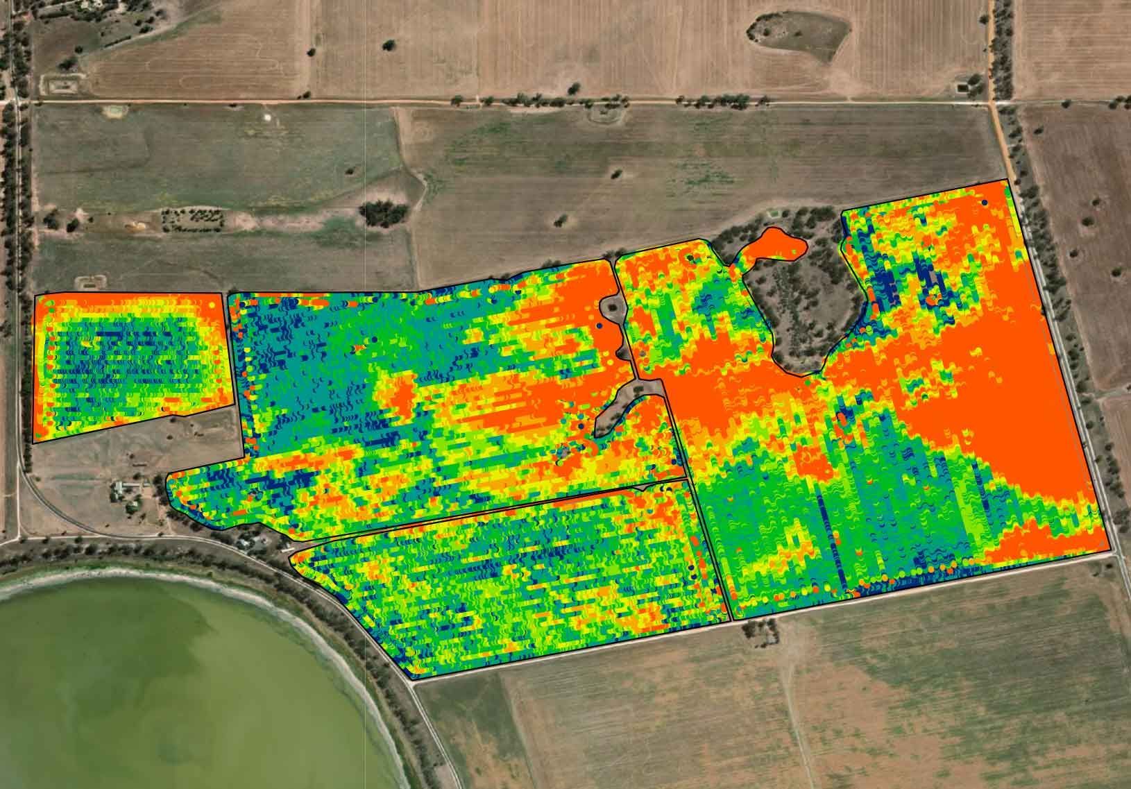
Get the most out of every part of your fields. Use multi-year STACK maps or Rapid-EM™ data to identify soil production zones.
RapidEM™
- Electromagnetic surveys for soil property mapping.
- Hire an EM machine — map it yourself and save.
- Simple setup. Automated data processing. Just attach and drive.
STACK Analysis
- STACK combines multiple years of satellite imagery to define production zones
- Converts directly into a prescription map so you can variably apply soil ameliorants such as lime and gypsum
- Pay as you go with Basic or Advanced subscriptions, or unlimited with Pro
Monitor by satellite to spot issues early.
Our base satellite imagery flies over every 5 days, and archives go back to 2017. If you want more detail on demand, then our high-resolution products can be captured down to 50cm pixel resolution.
- Satellite imagery helps you track plant health in real time.
- See weed pressure, crop stress, or nutrient deficiency before it becomes a problem.
- Cover large areas easily. Easy access on your phone or computer. Scout in the paddock with locate feature.
Free Standard Resolution Satellite Imagery
High resolution
Satellite Imagery
- Ideal for monitoring crop variability and performance in fine detail
- High resolution imagery gives you greater confidence in detecting issues that are difficult to see at ground level.
- Satellites are more cost effective than drones or planes, and data can be gathered over anywhere in the world.
Target applications of herbicide, fertiliser, or crop protection.
Use super high-resolution data to pin-point weeds and cut costs. Use satellite imagery, EM, or yield to adjust rates of fertilser and crop protection (herbicides, fungicides, desiccants, growth regulators).
- Use weedSAT™ to locate problem areas and reduce unnecessary herbicide use. Save time and cut spray costs by up to 80% with precision spot spraying.
- Use satellites instead of sensors. No additional hardware or software. 90% of booms are compatible.
- Use Super High Resolution imagery and our custom algorithms, to detect weeds and turn your conventional boom into a spot sprayer.
weedSAT™
Prescription Maps
- Generate variable rate prescription maps at any growth stage from satellite, yield, EM.
- Fertiliser. Seed. Chemical... all based on real-time paddock performance.
- Easy to load into your machinery screen.
- Create variable rate application maps from any data layer.
- Edit zones, draw your own, and batch process multiple fields to save time.
- Pay as you go – or go unlimited with Pro Subscription.
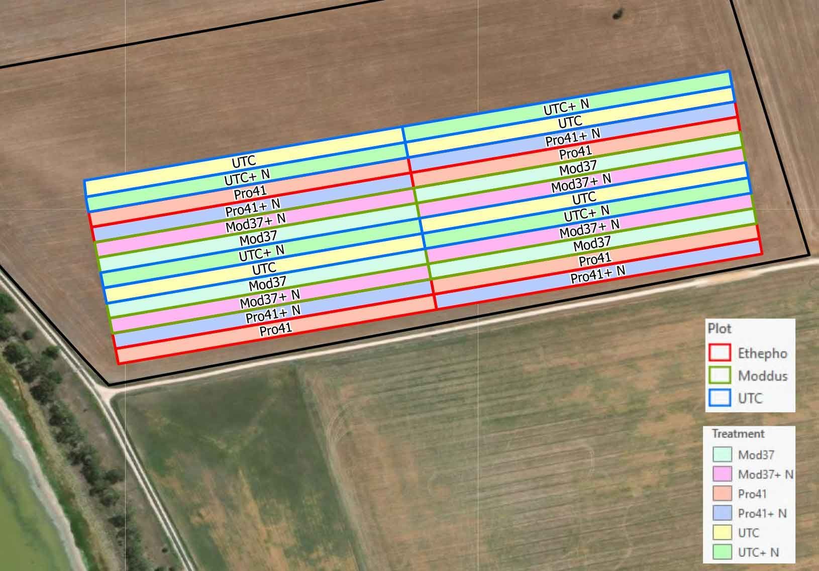
Analyse the results of your hard work.
Set up, monitor, and compare treatments with ease. Analyse and display yield to make better decisions.
- Review yield results.
- Compare treatments in field trials (coming soon).
- Automatically import your John Deere data
- No matter your setup, we’ll help you visualise your yield, so you can assess performance, and make informed changes.
- Included with a Pro Subscription.
Yield Analysis
Field Trials
- See what’s working — and what’s not.
- Included in both Advanced Subscription and Pro Subscription.
- Test seed, fertiliser and chemical rate responses
- Measure crop changes in satellite imagery to get a clearer picture
- Zonal responses mean picking the right rate for the right area in the next crop.
Ready to take control of your growing season?
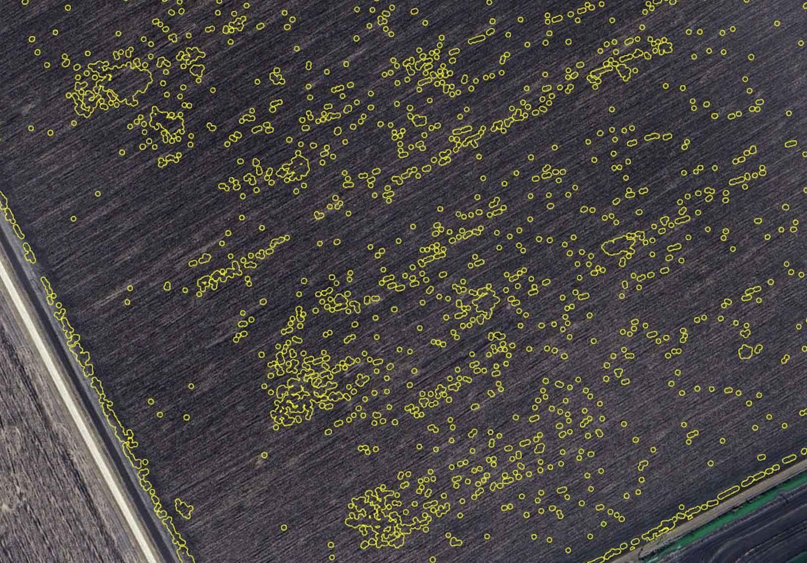
Introducing weedSAT™
Using military grade satellite imagery to detect weeds and turn your conventional boom into a spot sprayer.
Reducing herbicide use with satellite imagery.
Satellite data collection over fields
High-resolution satellite imagery is captured over cropping fields to monitor weed presence, Green on Brown (in fallow) currently available, with Green on Green in crop available soon.
Weeds detected and buffered
Advanced algorithms analyze the satellite data no detect and map the precise locations of weed infestations within the fields.
Sprayer treats only weed impacted areas
Sprayers apply herbicides specifically to the weed-affected zones, minimising chemical usage and reserving healthy crops. Any boom sprayer with section or nozzle control is likely to be compatible.
Reducing herbicide use with satellite imagery
Detect weeds using our specialised algorithms
weedSAT™ uses military grade satellite imagery to detect weeds using custom algorithms. Buffers around the weed and export to a file, ready for the sprayer to treat only weed-impacted areas.
WeedSAT is one of several technologies developed with investment from the Grains Research and Development Corporation (GRDC) through the Grain Automate project. Grain Automate is an initiative on behalf of Australian grain growers aimed at accelerating the adoption of machine automation, autonomy and digital technologies in the Australian grains industry. R&D investment in this technology does not indicate commercial product endorsement by GRDC. We also acknowledge the support of the University of Sydney in algorithm development.
Green on Brown
Weeds in fallows (gap between crops)
Green on Green
Weeds whilst the crop is growing
Cost effective
1/6th (or less) of the control cost
Reduce Herbicide Use
~70-80% reduction in herbicide use
weedSAT™ – Unbeatable value!
Drones
Spot Sprayers

No CapEx requirement
Scalability
Low cost per hectare pricing
Large areas covered quickly
Operator not required
WeedSat Calculator
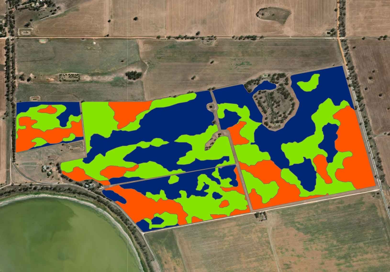
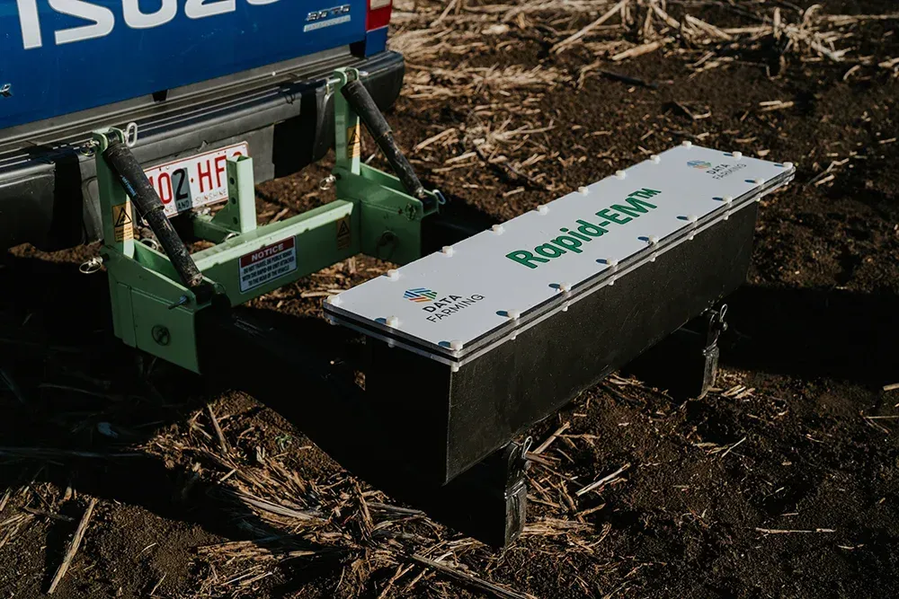
RapidEM™ – soil mapping tool.
A smarter, faster way to understand your soil — now available for on-farm use.
RapidEM™ is an autonomous soil electrical conductivity mapping solution that provides detailed information about soil type and soil properties to enable variable rate (VR) soil improvement applications.
EM measures soil types using a non-contact machine which measures 0.50m and 1.2m down into the soil profile. When combined with soil test data, we obtain a holistic picture of soil factors such as salts, water, and clay content.
The unit easily installs behind vehicles (in the towball hitch) and automatically logs data when moving around your paddocks. A key feature is that the RapidEM™ sends the data to the ‘cloud’, avoiding the need to shift data manually using USB’s, etc. The data is currently processed and available in our online platform.
RapidEM™ will be a great tool for agronomists who can now offer EM data collection and processing services.
Hiring the unit means agronomists don’t need capital outlay to get mapping, just a ute and willing customers. Farmers can hire the unit for $5/ha+GST with a minimum charge of $1200+GST per use.
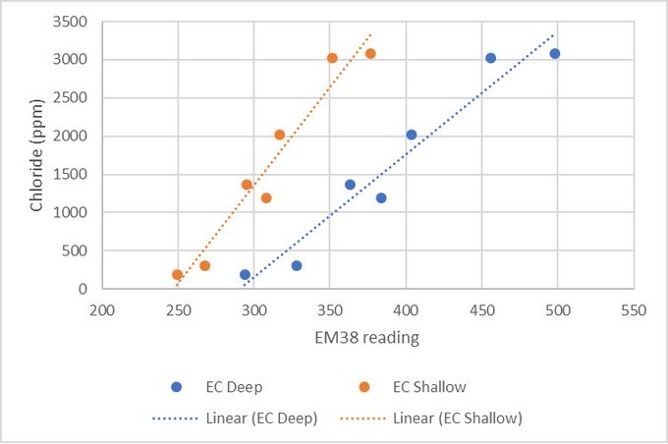
EM readings in this example are driven by salts (Chloride).
For Agronomists
Built for agronomy professionals managing multiple farms and teams
RECOMMENDED
Pro Subscription
For agronomists or larger operations.
- Unlimited access to John Deere yield, trials, variable rate prescription maps & STACK analysis
- Set up and manage farms and organisations with ease
- Includes expert support for data processing, conversions, and troubleshooting
- Ready to scale your agronomy services while adding more value to each visit? Go Pro and set up your organisation today.
Scale your advice. Strengthen every relationship.
Smarter insights, seamless collaboration, and tools built for modern agronomy.
- Most precision ag tools add more work to your day — they’re too complex, too expensive, and add too much time to your already stretched resources.
- DataFarming supports unlimited farms and clients, which means juggling data, paddock visits, and recommendations – all while making confident calls under pressure.
DataFarming brings together satellite imagery, strip trials, yield data, and prescription tools – all in one place. Simple, accurate, and built for modern agronomy.
Stay sharp. Stay trusted. Grow your business.
DataFarming gives you tools that help you scale your business and strengthen every client relationship.
Manage your team and clients in one place.
Set up an organisation to centralise billing, assign staff to set farms. Work better together with shared data and clear visibility. Collaborate between team members. Share farms with clients.
Create accurate plans. Faster.
Use STACK maps or RapidEM™ data to define soil zones, link them to test results, and generate multiple prescription maps in minutes. Save time, stay organised, and deliver tailored soil recommendations at scale to your clients. Make more money by hiring a RapidEM™ machine.
Unlock your soils' potential.
Get the most out of every part of your fields. Use multi-year STACK maps or Rapid-EM™ data to identify soil production zones.
RapidEM™
- Electromagnetic surveys for soil property mapping. Better target soil testing or placing soil moisture probes to get meaningful results.
- Hire an EM machine and map your clients’ farms. An additional revenue stream from offering additional services to your growers, whist improving your understanding of the soils in each paddock.
- Simple setup, GPS unit supplied to drive straight lines. Automated upload and data processing. No USB’s or complicated data transfer. Just attach and drive.
STACK Analysis
- STACK combines multiple years of satellite imagery to define production zones perfect for determining where to take soil samples, especially where no other data exists.
- Converts directly into a prescription map so your clients can variably apply soil ameliorants such as lime and gypsum. All done from your computer or tablet.
- Available unlimited with Pro. As many farms/paddocks/years you want. Additional revenue stream and better outcomes for your client.
Monitor by satellite to spot issues early.
Our base satellite imagery flies over every 5 days, and archives go back to 2017. If you want more detail on demand, then our high-resolution products can be captured down to 50cm pixel resolution.
- Scout smarter and never miss a thing.
- Save a bucket load of time.
- Satellite imagery helps you track plant health in real time every 5 days, for FREE.
- See weed pressure, crop stress, or nutrient deficiency before it becomes a problem.
- Gives you more confidence in your recommendations.
- Cover large areas easily. Easy access on your phone or computer.
- Scout in the paddock with locate feature. Share the farms with each of your growers for FREE.
Free Standard resolution Satellite Imagery
High resolution
Satellite Imagery
- Ideal for monitoring crop variability and performance in fine detail
- High resolution imagery gives you greater confidence in detecting issues that are difficult to see at ground level.
- Perfect for tissue sampling in high value/intensive crops or tracking issues like disease over time giving your more confidence in your recommendations.
- Satellites are more cost effective than drones or planes, and data can be gathered over anywhere in the world.
Target applications of herbicide, fertiliser, or crop protection.
Use super high-resolution data to pin-point weeds and cut costs. Use satellite imagery, EM, or yield to adjust rates of fertilser and crop protection (herbicides, fungicides, desiccants, growth regulators).
weedSAT™
- Use weedSAT™ to locate problem areas and reduce unnecessary herbicide use. Help your growers cut spray costs by up to 80% with precision spot spraying.
- Use satellites instead of sensors. No additional hardware or software. 90% of booms are compatible.
- Use Super High-Resolution imagery and our custom algorithms, to detect weeds and turn a conventional boom into a spot sprayer.
Prescription Maps
- Generate variable rate maps at any growth stage from satellite, yield, RapidEM™.
- Fertiliser. Seed. Chemical... all based on real-time paddock performance.
- Easy to get into machinery screens.
- Support from DataFarming technicians.
- Edit zones and rates.
- Batch process multiple fields to save time.
- Unlimited with Pro Subscription.
Analyse the results of your hard work.
Set up, monitor, and compare treatments with ease. Analyse and display yield to make better decisions.
Yield Analysis
- Review yield results without all the complicated software you dread. Compare treatments in field trials.
- Automatically import your clients’ John Deere data
- No matter your setup, we’ll help you visualise yield, so you can assess performance, and make informed changes.
- Included with a Pro Subscription.
Field Trials
- Get real data behind what’s working — and what’s not, not just gut feel.
- Included in both Advanced Subscription and Pro Subscription.
- Test seed, fertiliser and chemical rate responses to help you give better advice.
- Measure crop changes in satellite imagery to get a clearer picture.
- Zonal response mean picking the right rate for the right area in the next crop.
Ready to take control of your growing season?
Introducing weedSAT™
Using military grade satellite imagery to detect weeds and turn your conventional boom into a spot sprayer.
Reducing herbicide use with satellite imagery
Satellite data collection over fields
High-resolution satellite imagery is captured over cropping fields to monitor weed presence, Green on Brown (in fallow) currently available, with Green on Green in crop available soon.
Weeds detected and buffered
Advanced algorithms analyze the satellite data no detect and map the precise locations of weed infestations within the fields.
Sprayer treats only weed impacted areas
Sprayers apply herbicides specifically to the weed-affected zones, minimising chemical usage and reserving healthy crops. Any boom sprayer with section or nozzle control is likely to be compatible.
Reducing herbicide use with satellite imagery
Detect weeds using our specialised algorithms
weedSAT™ uses military grade satellite imagery to detect weeds using custom algorithms. Buffers around the weed and export to a file, ready for the sprayer to treat only weed-impacted areas.
Green on Brown
Weeds in fallows (gap between crops)
Green on Green
Weeds whilst the crop is growing
Cost effective
1/6th (or less) of the control cost
Reduce Herbicide Use
~70-80% reduction in herbicide use
weedSAT™ – Unbeatable value!
Drones
Spot Sprayers
No CapEx requirement
Scalability
Low cost per hectare pricing
Large areas covered quickly
Operator not required
RapidEM™ – soil mapping tool.
A smarter, faster way to understand your soil — now available for on-farm use.
RapidEM™ is an autonomous soil electrical conductivity mapping solution that provides detailed information about soil type and soil properties to enable variable rate (VR) soil improvement applications.
EM measures soil types using a non-contact machine which measures 0.50m and 1.2m down into the soil profile. When combined with soil test data, we obtain a holistic picture of soil factors such as salts, water, and clay content.
The unit easily installs behind vehicles (in the towball hitch) and automatically logs data when moving around your paddocks and displays in the cab in real time (see images below). A key feature is that the RapidEM™ sends the data to the ‘cloud’, avoiding the need to shift data manually using USB’s, etc. The data is fully integrated into our online platform.
RapidEM™ will be a great tool for agronomists who can now offer EM data collection and processing services.
Hiring the unit means agronomists don’t need capital outlay to get mapping, just a ute and willing customers. Agronomists can hire the unit for $4/ha+GST with a minimum charge of $900+GST per use. Additional revenue for your business by offering an EM mapping service.
EM readings in this example are driven by salts (Chloride).
We help you understand and serve your customers better.
- Scalable intelligence. Local precision. Built for agribusiness, government, and industry partners such as seed, fertiliser, and chemical companies.
- The Agri-Intelligence™ platform delivers custom-built solutions that combine regional-scale agricultural data with paddock-level precision, empowering industries to make faster, smarter, and more informed decisions.
What you can achieve
- Understand your market share
- Crop Type Identification across entire growing regions
- Automated Paddock Drawing across broad geographies
- Fallow Land Detection down to individual paddocks
- Soil Water Mapping available Australia-wide
- Logistics Support for planning and resource deployment
- Custom Analytics — tailored to your objectives and data
Why Choose Agri-Intelligence™
- Customisable to your region, crop, or operational needs
- Scalable architecture suited to national programs or local pilots
- Integration-ready with existing systems or workflows
- Backed by a team of agronomy and geospatial specialists
- Trusted by R&D teams, policy makers, logistics managers, and agribusiness leaders